Stay Up-To-Date

Subscribe to our mailing list to receive news releases and other materials related to Terra Clean Energy Corp. Your email will never be shared or sold and you can opt out at any time.

Thank you for subscribing!

We'll send you updates on our latest news and events.

Close

Powder Mountain

Project Overview

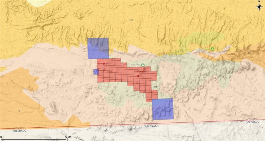
Terra Clean Energy has acquired by low-cost staking 3,395 acres of highly prospective uranium claims in southern Wyoming, adding a new U.S. uranium exploration asset to its growing portfolio.

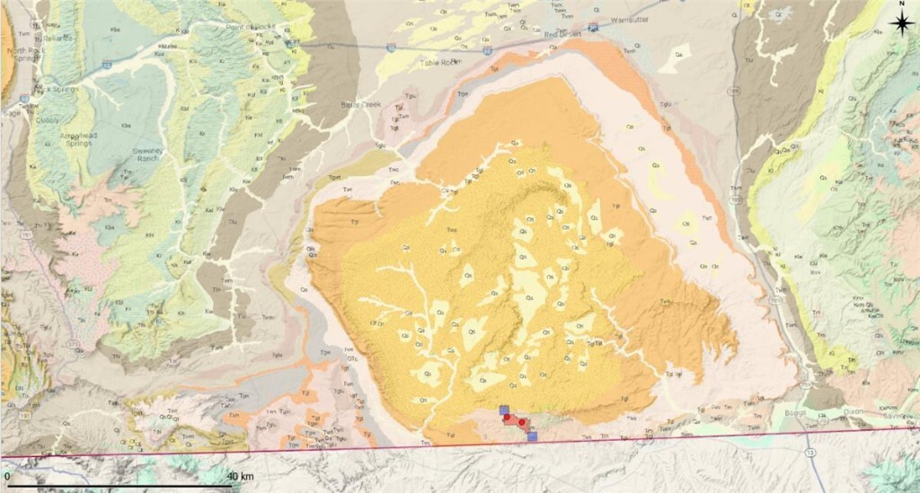
The acquisition consists of 100 unpatented BLM Lode Mining Claims covering 2,068 acres, plus three Wyoming State Leases covering an additional 1,327 acres—all 100% owned by the Company. The claims are situated along the south flank of the Washakie Basin, in close proximity to enCore Energy Corp's Juniper Ridge uranium deposit.

Two historical uranium occurrences have been identified within the staked ground, with the highest recorded grade of 0.375% U₃O₈—suggesting meaningful mineralization that has seen little modern exploration since the mid-1980s.

"We are extremely excited to add this highly prospective land in Wyoming in close proximity to enCore Energy Corp Juniper Ridge uranium deposit. The newly acquired lands are in a known uranium jurisdiction and have numerous uranium occurrences with the highest occurrence recorded at .375% U₃O₈."

- Greg Cameron, CEO
Topographic geological map showing staked claims in red and state leases in blue
Staked claims shown in red, state leases in blue. Light brown indicates the Browns Park Formation; red dots show identified uranium occurrences.

Project Highlights

Icon

3,395 Acres Acquired

100 BLM claims (2,068 acres) plus 3 Wyoming State Leases (1,327 acres), 100% owned by Terra Clean

Icon

Proven Uranium Jurisdiction

Adjacent to enCore Energy's Juniper Ridge deposit and near the historic Poison Basin 6.13M lb U₃O₈ deposit, 75km east

Icon

High-Grade Occurrences

Historical sampling from prospecting pits returned grades of 0.375%, 0.083%, and 0.058% U₃O₈

Icon

Underexplored Upside

Little modern exploration work conducted in the area since the mid-1980s—significant discovery potential remains

Geological Setting

Washakie Basin

A large syncline forming a topographic plateau south of Interstate 80 and west of State Highway 789, within the greater Green River Basin—a structural low known to host roll-front uranium mineralization.

  • Host Formation: Miocene-aged Browns Park Formation—light gray to buff tuffaceous sandstones, sandy tuffs, conglomerates, and quartzite.
  • Deposit Style: Sandstone-hosted roll-front uranium deposits, a well-established and productive model.
  • Historical Context: Conventional mining previously undertaken 75 km east at Poison Basin, home to a 6.13M lb U₃O₈ deposit.
  • Regional Analogue: Homeland Uranium Corp.'s Coyote Basin Uranium Project (~145 km south in Meeker, Colorado) contains a significant historical resource in the same formation.
Washakie Basin showing new claims and state leases on the south flank
Washakie Basin showing new claims and state leases on the south flank. Baggs, Wyoming is located in the southeast corner.